La Palma has more than 1,000 km of waymarked trails that wind through astonishingly diverse landscapes: from prehistoric laurel forests to volcanic craters, taking in coastal cliffs and summits perched above the clouds. Here is our pick of the best trails, with all the practical information you need to plan each one. If you are after general advice on kit, seasons and difficulty levels, have a read of our complete guide to hiking in La Palma first.
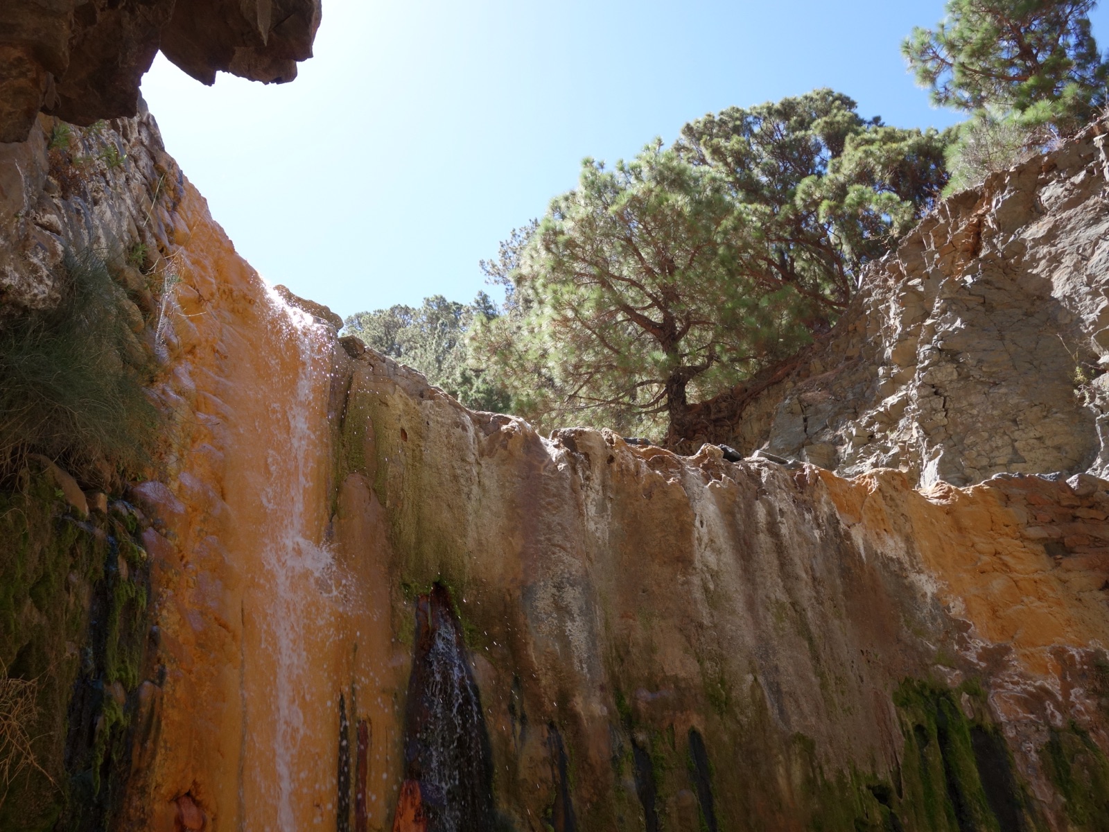
1. Caldera de Taburiente - Cascada de Colores
- Distance: 13 km (out and back)
- Elevation change: 850 m of descent and ascent
- Duration: 5-6 hours
- Difficulty: Moderate to hard
- Start: Mirador de Los Brecitos (reached by taxi from the car park)
The most iconic trail in La Palma and probably in all of the Canary Islands. You descend into the heart of the Caldera de Taburiente National Park through centuries-old Canary pine forest until you reach the Barranco de las Angustias ravine. The highlight is the Cascada de Colores, where waters laden with iron and other minerals have stained the rock in intense oranges, yellows and greens, creating a natural mosaic found nowhere else in the world.
The trail passes the Taburiente campsite, where you can stay overnight with a prior permit. The return along the same path is demanding because of the accumulated elevation gain. Take plenty of water and food: there are no supply points along the route.
2. Ruta de los Volcanes (GR-131)
- Distance: 17 km (point to point)
- Elevation change: 500 m net descent
- Duration: 5-7 hours
- Difficulty: Moderate
- Start: El Pilar refuge / Finish: Fuencaliente
The traverse along the volcanic ridge of southern La Palma is one of the most famous walks in the Canary Islands. You hike between volcanic cones from different eruptions, with views over the Atlantic Ocean on both sides of the island. The landscape shifts from pine forest to bare volcanic terrain, with craters in colours ranging from deep black to rust red. It is a point-to-point route, so you will need transport back (there is a bus service). The final stretch drops down to the Fuencaliente salt pans, where you can round off the day with a swim and some fresh fish.
3. Marcos y Cordero
- Distance: 12 km (point to point)
- Elevation change: 900 m of descent
- Duration: 4-5 hours
- Difficulty: Moderate
- Start: Casa del Monte (reached by 4x4 taxi) / Finish: Los Tilos
One of the most unusual walks in the Canary Islands, and possibly in all of Europe. The trail passes through 13 tunnels carved into the mountain to channel water from the springs. You will need a torch for the tunnels and a waterproof jacket, because water pours down heavily in several of them: you are going to get wet. The combination of walking through dark tunnels with the views over the Barranco del Agua amid laurel forest makes this a truly one-of-a-kind experience.
The start requires a 4x4 taxi from Los Sauces or San Andrés. The route ends at Los Tilos, where you can take the chance to explore the laurel forest.
4. Los Tilos Forest and Cubo de la Galga
- Distance: 5-8 km (depending on the variant)
- Elevation change: 300-500 m
- Duration: 2-3 hours
- Difficulty: Easy to moderate
- Start: Los Tilos Visitor Centre or the Cubo de la Galga car park
These two walks run through the laurel forests of north-eastern La Palma, designated a UNESCO Biosphere Reserve. The Cubo de la Galga is especially worthwhile: a circular route among giant ferns, trees draped in lichen and moss, and a humid atmosphere that transports you back millions of years. These forests are relics of the Tertiary period, survivors of the ice ages thanks to the islands' microclimate. They are ideal walks for families and for cloudy days when the summits are out of reach.
5. Ruta de la Crestería (GR-131)
- Distance: 15 km (point to point)
- Elevation change: 600 m of accumulated gain
- Duration: 6-8 hours
- Difficulty: Hard
- Start: Roque de los Muchachos
The walk along the rim of the Caldera de Taburiente is a high-mountain route that only experienced hikers should attempt. You walk along the ridge at more than 2,000 metres, with the abyss of the caldera on one side and the ocean on the other. The views are the most breathtaking in La Palma, but the route demands a head for heights, good fitness and favourable weather. It is not suitable for days with strong wind or fog.
6. Volcán de San Antonio and Teneguía
- Distance: 5 km (circular)
- Elevation change: 200 m
- Duration: 1.5-2 hours
- Difficulty: Easy
- Start: Volcán de San Antonio Visitor Centre, Fuencaliente
A short, accessible walk that circles the crater of the Volcán de San Antonio and comes close to the Teneguía, the last volcano to erupt in La Palma before the Cumbre Vieja eruption of 2021. The volcanic landscape, with sea views and the Fuencaliente salt pans in the background, is spectacular. Ideal for anyone who wants a volcanic experience without much physical effort.
7. Tijarafe coastal trail
- Distance: 6 km (out and back)
- Elevation change: 650 m
- Duration: 2.5-3 hours
- Difficulty: Moderate
- Start: Tijarafe village / Finish: Porís de Candelaria
The descent from Tijarafe down to Porís de Candelaria is a short but spectacular route. You make your way down the cliff face with sweeping views of the west coast and the ocean. Once at the bottom, you can pair the walk with a kayak trip to visit the Cueva Bonita and round off a perfect day of land and sea.
8. GR-130: Camino Real de La Costa
- Distance: 72 km (in stages)
- Elevation change: Varies by stage
- Duration: 4-5 days
- Difficulty: Moderate
- Start/Finish: Circular, from any municipality
The Camino Real de la Costa circles the whole island along the old paths that linked the towns before there were any roads. It can be walked in stages, staying overnight in each village. It is an extraordinary way to get to know La Palma in depth: the variety of landscapes, the local culture and the cuisine of each area. Every stage offers a completely different landscape.
General tips
- Check the weather forecast the day before, especially for summit routes.
- Always carry more water than you think you will need. The sun and wind dehydrate you quickly.
- Trekking footwear with a good sole is essential. The volcanic terrain is uneven and slippery.
- For point-to-point routes, find out about the bus (guagua) or taxi service for the return.
- Book access to the Mirador de la Cumbrecita if you are travelling in your own vehicle.
- Do not stray from the marked trails in volcanic areas: the ground can be unstable.
For more information on kit, seasons and difficulty levels, have a look at our complete guide to hiking in La Palma. If you would like to combine your walks with a day on the water, our kayak trips along the coast of Tijarafe are the perfect complement. Plan your whole trip with our 3-day and 7-day itineraries.