The Volcanic Route is probably the most spectacular hike you can do in the Canary Islands. Seventeen kilometres along the volcanic ridge of La Palma, walking literally along the edge of craters that erupted just a few decades ago. On each side, the Atlantic stretches to infinity. It is an experience that puts into perspective how small we are in the face of nature's power.
This guide tells you everything you need to know to complete the route: from how to reach the starting point to what to pack in your backpack, including what you will find along each section of the trail.
Technical details
- Distance: 17.1 km (linear, point to point).
- Elevation gain: +370 m / Elevation loss: -1,282 m.
- Duration: 6-7 hours (depending on pace and stops).
- Difficulty: moderate to high. It is not technical, but it is long and sun exposure is constant.
- Starting point: Refugio de El Pilar (1,450 m).
- End point: Fuencaliente Lighthouse (sea level).
- Recommended season: April to November. Avoid days of intense calima (Saharan haze).
Section 1: from Refugio de El Pilar to Hoyo Negro (5 km)
The route begins at the Refugio de El Pilar, a recreational area surrounded by Canary Island pines at 1,450 metres above sea level. The trail is perfectly waymarked with the white and red markers of the GR-131. The first few kilometres wind through a pine forest that gradually opens up as you gain altitude.
Upon leaving the forest, the landscape changes radically. Green gives way to the black, red, and ochre of the volcanic ash. You are entering the heart of La Palma's volcanic ridge, a chain of craters aligned from north to south that form the island's backbone.
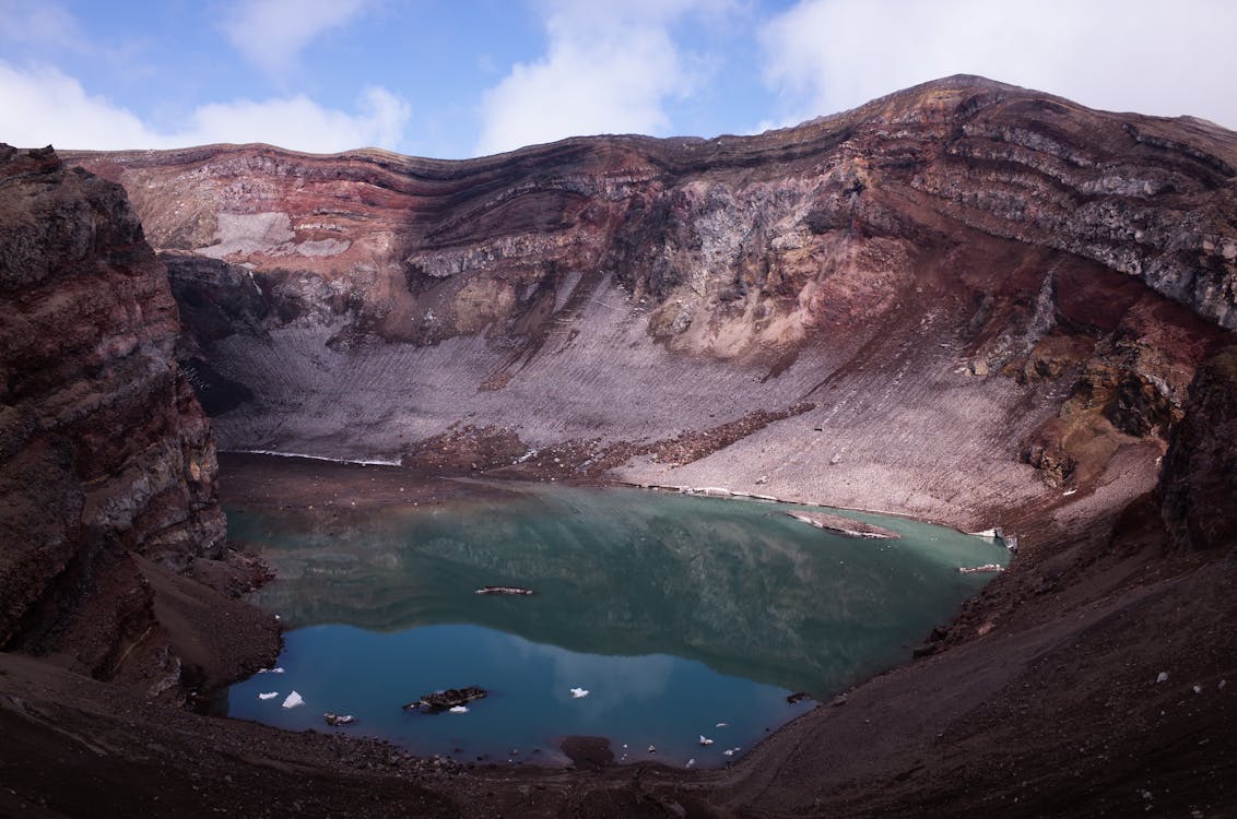
The first major crater you encounter is Hoyo Negro, a caldera with vertical walls and a dark floor that impresses with its depth. From the rim, the views towards both coasts of the island are breathtaking. On clear days, you can make out Tenerife, La Gomera, and El Hierro on the horizon.
Section 2: the volcanic ridge (5 km)
This is the most spectacular section of the route. The trail follows the ridgeline between Hoyo Negro and Deseada, walking along the crest of the ridge with the ocean on both sides. To the left, the east coast with its banana plantations and white villages; to the right, the western cliffs plunging into the sea.
The terrain is a mosaic of volcanic textures: black lapilli crunching beneath your boots, volcanic bombs scattered like sculptures, petrified lava flows frozen in whimsical shapes. Vegetation is minimal, the occasional Teide broom, some tussock grass, and the sensation is that of walking on another planet.
"Walking the Volcanic Route is like traversing the geological history of La Palma step by step. Each crater tells the story of an eruption, each layer of ash a chapter in the life of the island."
There is very little shade on this section. The sun beats down hard, especially in summer, and the reflection off the volcanic ash amplifies the heat. It is essential to bring a hat, high-protection sunscreen, and at least 2 litres of water. There are no water sources along the entire route.
Section 3: San Antonio and Teneguia volcanoes (4 km)
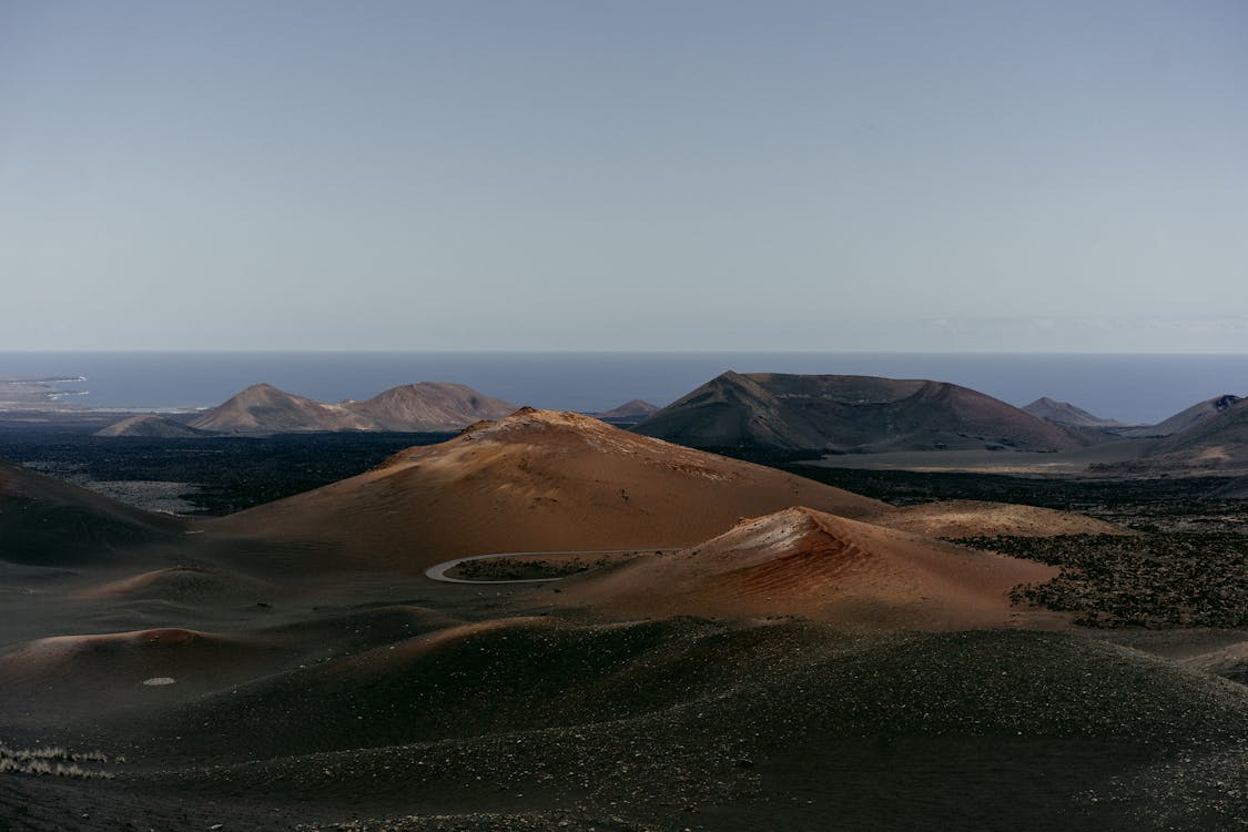
After leaving the ridge behind, the trail descends towards the youngest volcanoes on the island. San Antonio Volcano, which erupted in 1677, is now a broad and harmonious crater covered with pines that have gradually colonised its slopes. Next to it is the Visitor Centre, where you can take a break and learn more about La Palma's volcanology.
A few hundred metres away lies Teneguia, the youngest volcano in Spain (it erupted in 1971). Its crater still has active fumaroles that emit heat and a faint smell of sulphur. It is a reminder that La Palma is a living island, geologically speaking. The most recent eruptions on Cumbre Vieja in 2021 only confirmed this.
Section 4: descent to Fuencaliente (3 km)
The final section is a steady descent from the slopes of Teneguia down to the Fuencaliente Lighthouse at sea level. The landscape opens up completely: on one side, the Teneguia lava flows forming striking fields of black stone; on the other, the Malvasia vineyards that take advantage of the warm microclimate of the south to produce some of the finest wines in the Canary Islands.
Arriving at the bottom, the Fuencaliente Salt Pans appear like an abstract painting: rectangles of water in shades of white, pink, and ochre, framed by black lava and the blue of the ocean. It is the perfect ending for a route that has traversed the island from top to bottom, from forest to sea, from green to black.
Practical tips
- Transport: The route is linear, so you need to leave a car at the finish or use public transport. The guagua (bus) line 200 connects Los Llanos with Fuencaliente and passes through Refugio de El Pilar. Check updated timetables at transporteslapalma.com.
- Water: Bring at least 2 litres per person. There are no fountains or supply points along the entire route.
- Footwear: Hiking boots with good soles. Volcanic lapilli is abrasive and slippery.
- Start time: Set off early (before 8:00 AM) to avoid the hottest hours and have enough daylight remaining.
- Sun protection: Essential. Hat, SPF50+ sunscreen, and sunglasses. Volcanic ash reflects a lot of light.
- Vertigo: Some ridge sections can feel exposed. If you suffer from vertigo, consider whether this is the right route for you.
After the hike: recover with a kayak day
If the Volcanic Route has left you craving more adventure (and your muscles feeling a bit sore), we have the perfect complement: a kayaking day along the west coast of La Palma. Paddling is an excellent way to give your legs a rest after a long hike, and the perspective from the sea will give you a completely new view of the cliffs you saw from above.
Our excursion to Cueva Bonita departs from Porís de Candelaria and follows the coast of Tijarafe, right on the other side of the ridge you have just crossed. It is like completing the circle: yesterday you walked the summits, today you paddle along the base of the cliffs. La Palma in 360 degrees.